


Project NOAH

Descripción de Project NOAH
Project NOAH for Android
Enabling the mobility of Project NOAH. The official mobile version (native Android) of Project NOAH website (noah.dost.gov.ph) though without the Flood Map features.
This mobile app was developed by Rolly Rulete in cooperation with Project NOAH and with the partnership of Smart Communications, Inc. through the Smart Developer Network (SMART DevNet). Content and data come from the Department of Science and Technology (DOST) and its participating agencies.
Project NOAH’s (Nationwide Operational Assessment of Hazards) mission is to undertake disaster science research and development, advance the use of cutting edge technologies and recommend innovative information services in government's disaster prevention and mitigation efforts. Though the use of science and technology and in partnership with the academe and other stakeholders, the DOST through Program NOAH is taking a multi-disciplinary approach in developing systems, tools, and other technologies that could be operationalized by government to help prevent and mitigate disasters.
FEATURES:
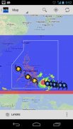
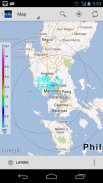
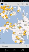
1. Map View
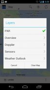
- PAR (Philippine Area of Responsibility)
- Overview (MTSAT, Rainfall Contours, Chance of Rain, etc)
- Doppler (Subic, Tagaytay, Cebu, Hinatuan, Tampakan)
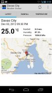
- Sensors (Weather Stations, Stream Gauges, Rain Gauges, Tide Levels)
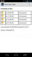
- Weather Outlook (Probablity of Rain, PAGASA Typhoon Forecast)
2. List View
- Almost the same with Map View but presented as list for ease of use.
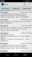
3. News
- DOST-PAGASA
- ClimateX
- PAGASA-FFWS (Flood Forecasting and Warning Section)
4. Help
- Help articles and guidelines
5. Info
- Information Dashboard
- Useful links and contents
* plus status notifications for "Probability of Rain"
* share screenshot (in almost all views) or text contents (News) via applications (Facebook, Twitter, Instagram, Bluetooth, Gmail, etc)
* the app is themeable! (Holo Light [default theme] OR Holo Dark)
* supports animated overlays (MTSAT, Doppler, Chance of Rain)
* improved caching for performance and offline usage
* very flexible Settings
keywords: DOST, PAGASA, NOAH, NDRRMC, nababaha, ClimateX, MMDA, SMART, SMART DevNet
</div> <div jsname="WJz9Hc" style="display:none">Proyecto NOAH para Android
Habilitación de la movilidad de los proyectos NOAH. La versión oficial de móvil (Android nativo) de la página web del proyecto NOAH (noah.dost.gov.ph), aunque sin las características mapa de inundación.
Esta aplicación móvil fue desarrollada por Rulete Rolly en cooperación con el Proyecto de NOAH y con la colaboración de Smart Communications, Inc. a través de la red de desarrolladores inteligentes (SMART DevNet). El contenido y los datos provienen del Departamento de Ciencia y Tecnología (DOST) y sus entidades participantes.
La misión del proyecto NOAH (Evaluación Operacional Nacional de Riesgos) es llevar a cabo la investigación en ciencias de desastres y el desarrollo, promover el uso de tecnologías de vanguardia y recomendar los servicios de información innovadores en los esfuerzos de mitigación y prevención de desastres del gobierno. Aunque el uso de la ciencia y la tecnología y en colaboración con el mundo académico y otras partes interesadas, el DOST a través del Programa NOAH está adoptando un enfoque multidisciplinar en el desarrollo de sistemas, herramientas y otras tecnologías que podrían llevarse a la práctica por el gobierno para ayudar a prevenir y mitigar los desastres .
CARACTERÍSTICAS:
1. Ver mapa
- PAR (Área de Responsabilidad Filipinas)
- Descripción general (MTSAT, lluvia Contornos, probabilidad de lluvia, etc)
- Doppler (Subic, Tagaytay, Cebu, Hinatuan, Tampakan)
- Sensores (estaciones meteorológicas, medidores de caudales, pluviómetros, niveles de marea)
- Perspectiva de Tiempo (probablity de lluvia, PAGASA Typhoon Forecast)
2. Lista
- Casi la misma con vistas Map pero presentó como lista para la facilidad de uso.
3. Noticias
- DOST-PAGASA
- Climatex
- PAGASA-FFWS (predicción de crecidas y la Sección de advertencia)
4. Ayudar
- Artículos y guías de ayuda
5. Info
- Dashboard Información
- Enlaces y contenidos útiles
* Notificaciones de estado, además de "probabilidad de lluvia"
* Cuota de pantalla (en casi todos los puntos de vista) o el texto contenidos (noticias) a través de aplicaciones (Facebook, Twitter, Instagram, Bluetooth, Gmail, etc)
* La aplicación es temable! (Holo Light [tema por defecto] o Holo oscuro)
* Soporta plantillas animadas (MTSAT, Doppler, Probabilidad de lluvia)
* Mejora de la memoria caché para el rendimiento y el uso sin conexión
* Los ajustes muy flexibles
palabras clave: DOST, PAGASA, NOAH, NDRRMC, nababaha, Climatex, MMDA, SMART, SMART DevNet</div> <div class="show-more-end">


